

Scoilnet Maps World Viewer Enhanced
16th September 2026
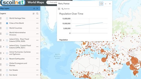
Scoilnet Maps has released an updated World Map Viewer featuring a wide range of new layers and improvements. The enhanced viewer is the latest development arising from the continuing partnership with Esri Ireland.
Among the features to note on the World Map viewer:
Basemap gallery options:
- Esri Streets
- Esri Topographical
- Esri Aeriel
- Open Streets (specifically relevant to JC and LC exams)
Built-in trustworthy layers that can be added to maps:
- World Heritage Sites
- World Countries
- Cities of the World (inc. population change over time)
- World Administrative Districts
- River Flooding (Ireland only from the OPW)
- Coastal Flooding (Ireland only from the OPW)
- Active Hurricanes, Cyclones & Typhoons
- Recent Earthquakes
- Global Ecoregions & Biomes
Widgets to enable user to engage with the maps:
- Measurement
- Coordinates
- Swipe & comparison between maps
- Elevation Profiles
- Add Data – allows the user to select from a massive range of other maps and add them to the map they are viewing, e.g. World shipping. But note that some of these may not be trustworthy.